| [ Login ]/[ Register ] |
 Search ::
  My Data Basket ::
  Favorite/My Favorite :: Recent Changes :: :: Login Save in Data Basket ]
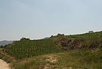
| Caption:碓臼坪长城 Photo Time:2008-07-24 14:01:30 Photo Contributor:内蒙古自治区文物局 [Open in New Window] |
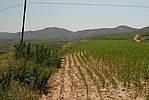
| Caption:碓臼坪长城 Photo Time:2008-07-24 14:05:01 Photo Contributor:内蒙古自治区文物局 [Open in New Window] |
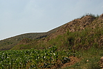
| Caption:碓臼坪长城 Photo Time:2008-07-24 14:08:29 Photo Contributor:内蒙古自治区文物局 [Open in New Window] |
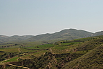
| Caption:碓臼坪长城 Photo Time:2008-07-24 14:13:07 Photo Contributor:内蒙古自治区文物局 [Open in New Window] |
| Caption:碓臼坪长城 Photo Time:2008-07-24 14:15:22 Photo Contributor:内蒙古自治区文物局 [Open in New Window] |