| [ Login ]/[ Register ] |
 Search ::
  My Data Basket ::
  Favorite/My Favorite :: Recent Changes :: :: Login Save in Data Basket ]
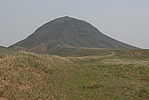
| Caption:双台子长城2段 Photo Time:2008-06-12 11:16:36 Photo Contributor:内蒙古自治区文物局 [Open in New Window] |
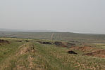
| Caption:双台子长城2段 Photo Time:2008-06-12 11:17:52 Photo Contributor:内蒙古自治区文物局 [Open in New Window] |
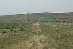
| Caption:双台子长城2段 Photo Time:2008-06-12 11:30:09 Photo Contributor:内蒙古自治区文物局 [Open in New Window] |
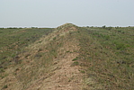
| Caption:双台子长城2段 Photo Time:2008-06-12 11:34:29 Photo Contributor:内蒙古自治区文物局 [Open in New Window] |