Official Name:
ЭЗЕРБпДхГЄГЧ5ЖЮTouDaoBianCunChangCheng5DuanOur Name:
УїГЄГЧЖўБп / MingChangChengErBian
Other Name:
/
Period:Уї / Ming Dynasty 1368~1644
Location: ФкУЩЙХзджЮЧј,ЮкРМВьВМЪа,аЫКЭЯи,Ц№ЕуЃКЕъзгеђЭЗЕРБпДхФЯ0.1ЧЇУзжЙЕуЃКЕъзгеђЭЗЕРБпДхЮї1.2ЧЇУз / NeiMengGuZiZhiQu,WuLanChaBuShi,XingHeXian,QiDianDianZiZhenTouDaoBianCunNan01QianMiZhiDianDianZiZhenTouDaoBianCunXi12QianMi
ЁЁ[
Looking Local List]
Details:ГЄГЧРрБ№ЃКЧНЬх
Ц№ЕуОЮГИпЖШЃКЖЋОЃК113Ёу 58Ёф ББЮГЃК40Ёу 36Ёф КЃАЮЃК1327
жеЕуОЮГИпЖШЃКЖЋОЃК113Ёу 57Ёф ББЮГЃК40Ёу 36Ёф КЃАЮЃК1468
ЧНЬхзпЯђЃКЧНЬхздЦ№ЕуЪМЯђЮїФЯбгЩьжСжЙЕуЁЃ
ЧНЬхРрБ№ЃКЭСЧН
НсЙЙЬиЕуМАЙЙжўЗНЪНЃКздШЛЛљДЁЩЯКЛжўЧНЬхЁЃ
ЯжзДЃКЭСЧНЁЃ
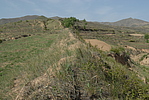
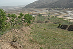
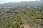
Type:ЭСЧН Rammed earth wall
Protection Level:Юо
ЁЁ
Content:
Memo:
Other Records:
Distribution:
visit location in Tianditu Map[recommend] Distribution:
visit location in Tencent QQ Map Distribution:
visit location in Google MapDistribution:
visit location in Baidu MapNational ID:150924382101170006
Action:[
 Save in Data Basket
 ]
Picture:
Click the thumbnail to view the Big Pic. Click the Big Pic to Hide the Big Pic![Caption:ЭЗЕРБпДхГЄГЧ5ЖЮ
loading images --Please wait...]()
![Caption:ЭЗЕРБпДхГЄГЧ5ЖЮ
loading images --Please wait...]()
![Caption:ЭЗЕРБпДхГЄГЧ5ЖЮ
loading images --Please wait...]() Photo Links
Photo Links:
ЁЁ Search ::
  Favorite/My Favorite :: Recent Changes :: :: Login