| [ Login ]/[ Register ] |
 Search ::
  My Data Basket ::
  Favorite/My Favorite :: Recent Changes :: :: Login Save in Data Basket ]
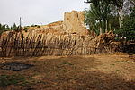
| Caption:塌崖畔村1号马面 Photo Time:2008-05-29 08:49:07 Photo Contributor:陕西省文物局 [Open in New Window] |
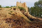
| Caption:塌崖畔村1号马面 Photo Time:2008-05-29 08:49:56 Photo Contributor:陕西省文物局 [Open in New Window] |
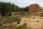
| Caption:塌崖畔村1号马面 Photo Time:2008-05-29 08:52:14 Photo Contributor:陕西省文物局 [Open in New Window] |
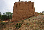
| Caption:塌崖畔村1号马面 Photo Time:2008-05-29 09:00:36 Photo Contributor:陕西省文物局 [Open in New Window] |